
How Might We Compare and Contrast Three Early Civilizations?
How Might We Compare and Contrast Three Early Civilizations?
This complete module with links to all materials may be downloaded as a PDF here.
Trish King
Girls Preparatory School
Chattanooga, TN
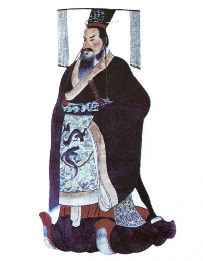
Qin Shi Huangdi. Source: Wikipedia at https://tinyurl.com/y9bcul62.
Estimated module length: four to six class periods of approximately an hour each
Overview
This module was designed for a sixth grade Global Cultures class although it could be implemented in classes ranging from sixth through ninth grade studying history, geography, and culture. The module is utilized in a private school, but also includes content that address relevant Tennessee middle school state World History and Geography Standards. Examples include 6.32—“Analyze the influence of geographic features on the origins of ancient Chinese civilization in the Yellow River Valley, and explain how China’s geography helped create a unique yet diverse cultural identity that was isolated from the rest of the world,” 6.35—“Explain the significance of the unification of ancient China into the first Chinese empire by Qin Shi Huangdi, beginning the Qin Dynasty,”6.25—“Identify and locate geographical features of ancient India including the Ganges river, Himalayan mountains, indian ocean, indus river, monsoon winds, and the subcontinent of India,”6.26—“Explain the emergence of the Harappan civilization in the Indus River Valley as an early agricultural civilization, and describe its achievements including architecture built with bricks, arranging roads into a series of grid systems, and sanitation and sewer systems,”6.55—“Describe the characteristics of Julius Caesar’s rule including: leadership in the military, popularity among plebeians, role as dictator for life, and assassination,” and 6.56—“Analyze the influence of Augustus Caesar, including the establishment of the Roman Empire and its political, geographic, and economic expansion during the Pax Romana.”
Historical context
Rather than studying each civilization in isolation, this module enables students to evaluate civilizations comparatively in their own times and in terms of their legacy. In “Teaching Early China and Ancient Rome Comparatively,” Berea College China specialist Jeffrey Richey (in reference to studying Ancient China and Rome) argues that to study these cultures is to examine how human beings in widely separated geographical areas coped with similar challenges and circumstances.” This module will provide an opportunity to compare geography, writing systems, government, infrastructure, defense, as well as innovations and contributions
Objectives
Students will be able to:
Locate, label, and describe the physical features of the early empires in China and India, as well as the Roman Empire.
Identify and describe the impact of significant accomplishments, developments and innovations from India, China, and Rome.
Consider the type of conclusions that can be drawn and the questions that arise when one examines ancient artifacts.
Examine historical maps from different times and places to compare them to modern maps and analyze the differences between them and the possible reasons for such differences.
Compare and contrast early civilizations using maps, primary sources, and a mini-research assignment.
This module can be used to implement a thematic approach to teaching India, Rome, and China, with the teacher augmenting inquiry-oriented activities with teacher-centered instruction and other strategies to provide varied content coverage. The module could also be split into parts, with the brainstorming and geography activities used before teachers introduce the student to each civilization. With this approach, the comparative research component occurs at the end of the module and both assists students in more broadly understanding civilizational similarities and differences and potentially can serve as a teacher assessment tool.
Prerequisite knowledge:
Students should have experience in using maps, an atlas, and websites to label and add features to maps. They should be familiar with key vocabulary: civilization, legacy, innovation, and empire. It would be helpful if students are experienced with reading and interpreting primary source documents, though it is not assumed that they will be.
This module could be used to frame a thematic approaching to teaching India, Rome, and China, with the teacher framing and filling in the materials with direct instruction and other strategies to provide balanced coverage. The module could also be split into parts, with the brainstorms and geography pieces used before the classroom teacher introduces the student of each civilization. With this approach, the research piece would come at the end of the module and could serve as a wrap-up and assessment. Depending on the teacher preference and intent, prerequisite knowledge will vary.
Module introduction
The additional worksheets and other materials for this module appear in both the module narrative and are listed at the end of the module for the convenience of teachers wishing to use all or part of these digital materials.
Estimated time: Approximately two hours total for both days
Brainstorm
(five to fifteen minutes, this can be completed individually in notebooks or as a whole class in discussion, depending on time constraints and whether or not you would like students to have a written record of their thoughts)
What makes a civilization or an empire “great?”
How might we learn more about ancient civilizations?
How can you measure the impact of an invention or other accomplishment?
How might we compare and contrast civilizations to better understand their history and legacy?
How did these civilizations interact and how did they view each other?
Video Trailers
(eight to ten minutes)
Show some or all of these quick clips to give students a quick look at what they will learn about in this module.
“Indus River Valley Civilization” Two minutes, forty seconds long clip from PBS FIRST CIVILIZATIONS
“The Discovery of the First Chinese Writing” Two minutes, thirty-nine seconds long clip from PBS STORY OF CHINA
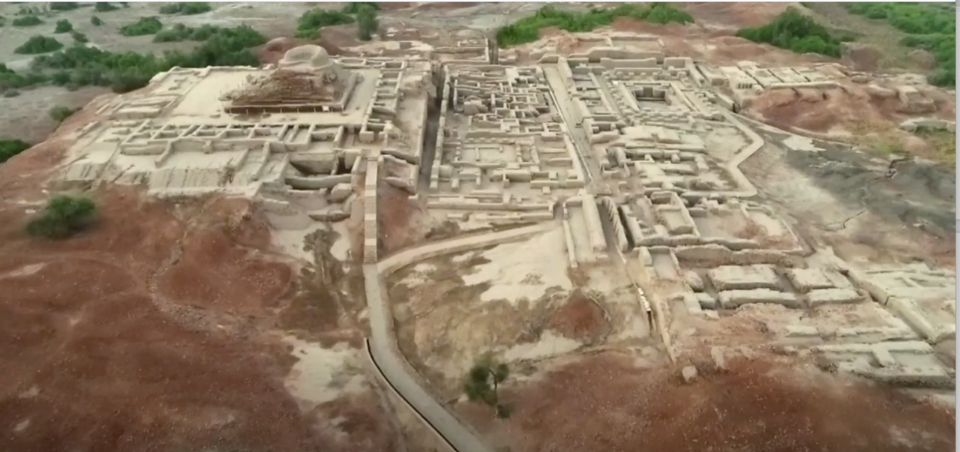
Screen Capture from Indus River Civilization by PBS. Source: https://tinyurl.com/yd38hb25.
Setting the Stage with Maps
Activity 1: Comparing Historical Maps
Use Handout 1, Comparing Historical Maps. The handout contains questions for students, content on the relationship between cartography and culture, and three early maps: one of the world, one of Rome, and one of China. Students will describe what they see, look for similarities and differences and evidence of different world views and priorities. Students will also record their questions or âwonderingsâ for use later in the module.
Activity 2: Labeling and Captioning Maps
Students start by thinking about their own home town to describe the ways in which geography might shape a place and determine how people live. They will use Handout 2, Setting the Stage with Maps, for better understanding of the relationship between geography and culture.
Students will then start working on early empire maps China Early Empires, India Early Empires, and Roman Empire 500 AD from the website PHSchool by labeling the cities, bodies of water, mountains deserts, provinces, countries, and continents provided in a list on the student handout. They will then write captions for the italicized items that describe their significance and impact on the early empires.
On the fourth and last map of the world, students will create a key and lightly shade the territories of the empires on one map to see them in relation to each other.
After the labeling, coloring, and captioning is complete, students will revisit the initial brainstorm questions and connect this work to the first map activity.
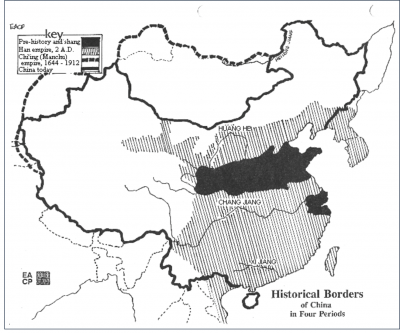
Historical Borders of China in Four Periods. Source: Asia for Educators at https://tinyurl.com/y7vjs4p9.
Authorâs notes on student reactions
Students needed prompting to think specifically about the ancient world given our class is rooted more in the present, however they were much better prepared to think about geography and its impact. They noted location could determine weather and the likelihood of natural disasters like earthquakes, physical features can encourage or limit interactions with other people, it will shape the economy, it relates to safety, it determines architecture, clothing, as well as health and diet.
Class No.3 How might we learn more about these civilizations?
Estimated time: Approximately fifty minutes to one hour
Activity 1 -- What can we learn from artifacts?
First distribute Handout 3 entitled Analyzing Historical Artifacts to the class.
Have the class view the seventeen-minute long TED Talk by Rajesh Rao âA Rosetta Stone for a Lost Language.â where the author, a computer science professor tells the story of his work to decipher the Indus River Valley written script. Before viewing, they should complete two questions, while viewing, they complete several others, and when finished, they use the Creative Questions Visible Thinking routine to examine objects from each of the three civilizations. This activity will provide students with an opportunity to use three museum webpages to look for answers to their questions and to the complete an activity where they will choose a question to imaginatively explore by playing out its possibilities by writing a story or essay, drawing a picture, creating a play or dialogue, inventing a scenario, or conducting an imaginary interview
Class Nos. 4 and 5: How might we compare the contributions of these civilizations?
Estimated time: Approximately two hours.
In the final comparative civilizations work, students conduct further research on early China, India, and the Roman empire.
Introductory Activity
Estimated fifteen to twenty minutes: minutes in partners, up to a whole class period if the options are projected and the two activities are completed with group participation and explanation of reasons behind proposed rankings.)
Using Handout 4, Student Research Handout, students will work in pairs to read and discuss a list of innovations and developments so they will be able to rank them in order of their importance to the world.
It would be helpful for students to start by accessing the timeline feature in the Ancient History Encyclopedia. Here students can search by category, by civilization, or by keyword. The timeline results include short passages that should provide students with some context to further research the items they have chosen. Similarly, the Directory of the Smith College Museum of Ancient Inventions can provide students with a brief description, time periods, and associated empires for the artifacts that appear in the museum collection (which include several from the list of choices.) The context in these sources will allow students to choose suitable next sources from the Student Sources for Research Activity list provided on page 8.
Research and Sharing findings
Teacher will help students choose one innovation to share with the class so that a wide range of contributions will be covered.
To prepare, students will complete the âI used to think, Now I know, But I still Wonder âprotocol to reflect on their prior thoughts.
Presentations should cover their initial thoughts about the importance, when they thought it had been developed, which group or groups they believed to have been responsible for it, and the new information they uncovered in their research.
Reflection
Each student will look at their initial rankings and decide which changes they would make to their original thoughts, if any. Additionally, students should look back on their âwonderingsâ throughout the module to see which of their questions have been addressed and which have not.
Optional Homework
Choose questions from remaining âwonderingsâ to research and record findings.
Authorâs notes on student reactions
Students needed much more time than expected to rank the items and there were almost no patterns in their responses. Teachers may wish to limit their list to fewer items that our most relevant to your teaching goals or essential questions. In terms of the impact of an event or accomplishment the majority felt it was best measured by the number of people who used it then and continue to use or need it now. Only one student suggested evaluating any changes or shift the invention may have triggered. They were consistently surprised by the contributions of the Harappan Civilization, partly because they had never heard of it and partly because of how early the civilization flourished.
References and resources:
Jeffrey L. Richey, âTeaching Early China and Ancient Rome Comparativelyâ Education About Asia 13, no. 2 (Fall 2008).
Tansen Sen and Victor H. Mair, Traditional China in Asian and World History (Ann Arbor: Association for Asian Studies, Inc., 2012).
Richard H. Davis, Global India circa 100 Ce: South Asia in Early World History (Ann Arbor: Association for Asian Studies, Inc., 2009).
https://www.pbs.org/video/indus-valley-civilization-ufdsp9/: A video on the âIndus River Valley Civilizationâ from PBS
https://www.pbs.org/video/discovery-first-chinese-writing-0nuw50/: Video on âThe Discovery of the First Chinese Writingâ from PBS.
https://www.youtube.com/watch?v=P0zrLZrlyko: âChandragupta, Ashoka and the Maurya Empireâ video by the Khan Academy on YouTube.
https://www.youtube.com/watch?v=EZWy7IFBCEQ âGupta Dynastyâ video from Khan Academy on YouTube. An overview of accomplishments in Indiaâs golden age.
http://avalon.law.yale.edu/ancient/twelve_tables.asp: âThe Twelve Tablesâ entry from Yale Universityâs Avalon Project.
http://www.cs.colostate.edu/~malaiya/ashoka.html: âKing Ashoka: His Edicts and His Timesâ from the Colorado State University website
https://dharma-documentaries.net/the-indus-valley-the-masters-of-the-river âThe Indus Valley (The Masters of the River)â video on YouTube via the Dharma Documentaries website
https://www.nytimes.com/2010/09/28/arts/28iht-melvin.html: The New York Times article âMissionary to the Forbidden Cityâ by Sheila Melvin from September 27, 2010.
http://www.myoldmaps.com/maps-from-antiquity-6200-bc/: Index of Cartographic Images illustrating maps from the Ancient Period: 6,200 B.C. to 600 A.D.
http://www.henry-davis.com/MAPS/AncientWebPages/AncientL.html: Index of Cartographic Images illustrating maps from the Ancient Period: 6,200 B.C. to 400 A.D. A digital collection of cartographic Images sponsored by Henry Davis Consulting.
https://en.wikipedia.org/wiki/Tabula_Rogeriana#/media/File:TabulaRogeriana_upside-down.jpg Tabula Rogeriana 1154 A.D. Muhammad al-Idrisi. Restored by Konrad Miller in 1927
http://cartographic-images.net/Cartographic_Images/115_Strabo.html: Straboâs World Map from the Henry Davis Consulting cartographic maps collection.
https://en.wikipedia.org/wiki/Pomponius_Mela: Pomponius Melaâs World Map A.D. 37 Reconstruction by Konrad Miller 1898 on Wikipedia.
http://www.henry-davis.com/MAPS/AncientWebPages/118.html: The Roman Map Reconstruction. Orbis Terrarum A.D. 20. Marcus Vipsanius Agrippa. Reconstruction from Raisz. From the Henry Davis Consulting cartographic maps collection.
http://www.phschool.com/curriculum_support/map_bank/pdfs/China_Early_EmpiresA.pdf: Early Empires in China map from PH School
http://www.phschool.com/curriculum_support/map_bank/pdfs/India_Early_EmpiresA.pdf: Early Empires in India map from PH School
http://www.phschool.com/curriculum_support/map_bank/pdfs/Roman_Empire_500AD_A.pdf: Map of the Roman Empire to 500 AD from PH School
http://www.phschool.com/curriculum_support/map_bank/pdfs/the_world_reliefA.pdf: World Map from PH School
https://www.archives.gov/files/education/lessons/worksheets/written_document_analysis_worksheet_novice.pdf.: Primary Source Analysis Guide by the Library of Congress.
http://afe.easia.columbia.edu/china/geog/maps.htm#1a: Chinese Geography Readings and Maps by Asia for Educators
http://www.perseus.tufts.edu/hopper/text?doc=Perseus%3Atext%3A1999.01.0239%3Abook%3D2%3Achapter%3D5%3Asection%3D17: The Geography of Strabo. Literally translated, with notes, in three volumes. London. George Bell & Sons. 1903. Book II, Chapter 5. Section 17. From the Tufts University Perseus Digital Library
www.loc.gov/item/2007626789/: Idrisi, Approximately, and Konrad Miller. Weltkarte des Idrisi vom Jahrn. Ch., Charta Rogeriana. Stuttgart: Konrad Miller, 1928. Map. Retrieved from the Library of Congress.
http://www.myoldmaps.com/book-v-53-world-maps-in.pdf
http://www.ruf.rice.edu/~asia/CartographyPaper.html Richard J. Smith, Rice University, article, âMapping China's World: Cultural Cartography in Late Imperial Times. Early World Maps in China.â
http://www.gutenberg.org/files/2124/2124-h/2124-h.htm: The Project Gutenberg EBook of Record of Buddhistic Kingdoms, by Fa-Hsien Translator: James Legge
Release Date: March 28, 2006 [Ebook #2124] Last Updated on January 26, 2013
https://www.ted.com/talks/rajesh_rao_computing_a_rosetta_stone_for_the_indus_script: âA Rosetta Stone for a Lost Language.â A TED talk video by Rajesh Rao from 2011.
https://www.metmuseum.org/toah/works-of-art/49.40.1/: Image of Stamp Seal and Incense Burner by the Metropolitan Museum of Art.
https://www.metmuseum.org/toah/ht/02/ssa.html: Timeline of Art History by the Metropolitan Museum of Art.
http://www.nationalmuseumindia.gov.in/en/collections/index/6: Prehistory and Archaeology by the National Museum of India.
http://afe.easia.columbia.edu/china/geog/M_Wall.htm: Map Grand Canal and Great Wall by Asia for Educators.
http://afe.easia.columbia.edu/china/geog/maps.htm#2f: Descriptions for Captions of China Map from Asia for Educators.
http://www.britishmuseum.org/research/publications/online_research_catalogues/rrc/roman_republican_coins/a_guide_to_types.aspx: The British Museum Guide to Roman Republican Coins.
https://www.nationalgeographic.com/history/history-magazine/article/roman-aqueducts-engineering-innovation: âAqueducts: Quenching Romeâs Thirstâ article by National Geographic
http://www.pbs.org/wgbh/nova/ancient/roman-aqueducts.html: âNOVA Watering Ancient Romeâ article by PBS.
https://interestingengineering.com/roman-arch-bridges-weight-hold: Interesting Engineering Roman Arch Bridges: How Much Weight Can They Hold by the Interesting Museum website.
http://afe.easia.columbia.edu/ps/cup/oracle_bone_general.pdf: Oracle Bone Inscriptions of the Late Shang Dynasty from Asia for Educators.
https://tn.pbslearningmedia.org/resource/moveable-type-story-of-china/moveable-type-story-of-china/#.WqaQQZPwagQ: âInventions and Science: Movable Type, The Story of Chinaâ by PBS Learning Media.
https://tn.pbslearningmedia.org/resource/astronomical-clock-story-of-china/astronomical-clock-story-of-china/: Inventions and Science: Astronomical Clock and Other Advancements, The Story of China by PBS Learning Media
https://www.khanacademy.org/humanities/world-history/world-history-beginnings/ancient-india/a/the-indus-river-valley-civilizations: âIndus River Valley Civilizationsâ reading by Khan Academy.
https://china.usc.edu/sites/default/files/forums/Chinese%20Inventions.pdf: âTop 20 Ancient Chinese Inventionsâ by the University of Southern California USâChina Institute.